
I have been a loyal Verizon customer since I signed my first contract years ago and have been waiting impatiently for Apple to offer an iphone on the V network so I could jump in the happy walled iphone garden. And now I have. Now that I have access to the app store, I've been downloading and playing with a bunch of aviation apps and thought I'd pass on what I've found so far.
DTC Duat:
Cost: Free
http://itunes.apple.com/us/app/dtc-duat/id396959302?mt=8
This is a pretty good little program that fairly well mirrors the user experience of the online Duats system. What I mean by this is that just like the online version, you get a lot of functionality on a somewhat finicky system without much regard for user interface (UI). However you do get a solid list of functions including:
- TFRs both graphical and text
- Briefings, route, area, state, and specific
- Weather including radar, winds aloft, and prognosis charts
- Flight plans, you can actually file a flight plan with a FREE App! - Best Feature?
- Flight planner - not user friendly but works
- Charts, airport info with taxi-way data, approach plates (I don't know if Id use the approach plate on an actual IFR - not even sure that it's officially approved for actual IFR use, it seems a little small for reading while flying, however if you find yourself without the correct chart I'm sure you could make it work).


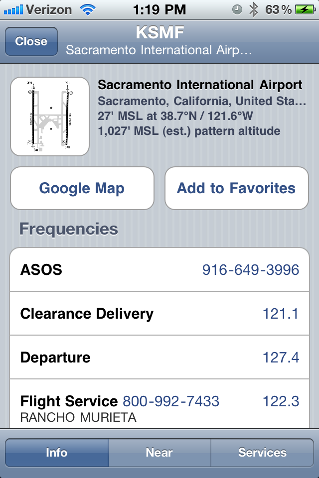
AOPA:
Cost: Free
This is a fairly simple App and is a bit more user friendly than the DUATs app for finding airports. They give really clear information about each airport that you are looking into in terms of frequencies phone numbers for flight service and ASOS, however their airport charts are almost bad with almost no usable info. Compare the same KSMF chart from AOPA with the one above from DUATs:

The AOPA airports app does a good job of giving you other details about airports you are traveling to including car rental options, local hotels and restaurants as well as FBO contact information. Had this been a paid app though, I think I would have been disappointed. At least put the taxi-way designations and maybe a little FBO flag on the chart or something . . .
AeroPlus:
Costs: Free (can you see a trend in my spending patterns?)
This is a simple little app that works really well. I like it. You open this app to a map screen centered at your location (assuming you've allowed location services on your phone) with green dots indicating all the weather stations near your location. if you hover over a location it will indicate some basic wind/weather details and if you click on the airport it will open a little box giving more in depth details:


To sum it up. If you are looking for a quick weather reference to get a better picture of the weather patterns in your area, this is a perfect app. You can quickly get an indication of weather on a planned route without needing to know the exact weather station identifiers along the way which is the case with the DUATs program. If the route is VFR the station will have a green dot, if the station is currently reporting IFR, it will be depicted as a red dot. If it's in between, an orange dot.
AeroWeather:
Cost: Free
This is another basic weather program. The idea here is that you program in a few stations, I'm guessing either local or on a planned route, then the app will list weather and wind in a really easy to read format for each of the airports you have chosen. Then you can click on any airport to get additional information. I like that the airport info page shows sunrise and sunset time and really does a good job of listing weather details in plain English. It also has a virtual red windsock on the stations page and VFR/IFR flag for each airport which is handy. I can't find a mapping feature, however I can imagine that the info provided could still be informative without a map.


iE6B:
Cost: Free
So here's an app that really provides a ton of functionality and usefulness at a cost I can afford! Here's a list of its basic functions:
- Solve for Time
- Solve for Speed
- Solve for Distance
- Wind Correction Angle/Groundspeed
- Headwind/X-wind
- Wind Effects
- Pressure/Density Alttitude (very helpfull)
- True Airspeed
- Programable Weight and Balance Template
- Fuel per Distance
- Endurance
- Volume Weight conversion
- + a host of other unit conversions
The only problem with this app is that the input fields are controlled by a sliding bar not a number pad and the sliding bar is extremely sensitive. I was trying to get a field elevation of 67 for a density calculation and the closest I could manage was 75 due to the touchy bar. So far I've only used this app for density calculations but I've played with the other features and I think its a fairly quick/easy solution to in flight math. Note: I've since found that if you tap in the box indicating the selected value (in the wind components image, the "12" would be the value I am referring to) a number pad pops up allowing you to enter a number without worrying about touchy slider input.
Images:


Now, there's one almighty app which is essentially the do-it-all handyman of aviation apps and has gained plenty of deserving attention - ForeFlight Mobile. It has all the features I could ever want (until more come out of course, then I want those too!) from mapped weather, to current GPS enabled flight path data, charts, plates, taxi diagrams, full weather briefings, flight plan filing and the list goes on. I can see why pilots are raving about this stuff. But here's my problem: at $74.99 for a one year subscription, my meager 12-15 mostly LCL attempts at remaining a current pilot hardly justify an Uber expensive app such as ForeFlight, even though I want it so badly. But here's what I tell myself: ForeFlight is an amazing app, yet the iphone isn't really the right application for the program and while it would be fun to look at on the ground, the screen is a bit too small to make it really useful in the air. When I'm able to afford both the ipad, and more frequent cross country flights, I think spending the extra money each year would be well worth it. For now, I'll satisfy my appetite for igagety toy apps by downloading ten different cheap or free apps and hope they together will come close to doing what ForeFlight is capable of. I'll note that Garmin also has an app called Garmin Pilot My Cast which is supposed to have similar functionality. I downloaded ForeFlight on my iphone but planned the timing wrong as I wasn't able to fly during the 30 day free trial period that they offer. But from the ground, it seems user friendly and full of functionality.
So what's my overall take on the igadgets? The many weather services available for the iphone make on-the- go and away from the computer weather checks much smoother and quicker. I'd note that when in doubt, you should always make a phone call to 1800 WX BRIEF to speak with a real human, however the visual sense of the weather in your region via the various apps can really help to give you a perspective of current and forecast conditions as you are getting closing to your flight time. And the iE6B is a really nice tool that makes my old rotary phone tech E6B seem clunky and outdated. I have yet to use any of these apps in the cockpit, but I'll make sure to send an updated if I have the opportunity to use these on an actual flight.
While not an actual aviation tool, I downloaded the LiveATC app which is a great little app if you ever feel like listening in on any of the major tower frequencies. Fun, mostly pointless, but still somehow worth the 3 bucks they charge for the app. Check it out:
No comments:
Post a Comment